Monday, May 16, 2011

Mount Lemmon Lookout Trail

Lemmon Lookout Trail
Santa Catalina Mountains
Length: 5 miles round trip
Change in elevation: 1800 ft.
Time it took us: 5 hours (including breaks)


After last week's adventure and this week's rising temperatures, I thought it would be nice to escape the heat for a bit and ascend Mount Lemmon. It was a little bit of a problem though finding a trail that looked easy enough for us to venture on and not be out all day. Last night I finally found this trail which is just under 5 miles. Cool!

We started a little later than usual. David "slept in" until 6:40 and we were out the door by 7 thanks to my super-organized packing and loading last night. We made a quick stop at Starbucks and then made the long trek up the mountain. We were slowed a bit by the Mount Lemmon bike time trials, but it was really cool to see all the bikers out there cranking it up the hill.

We reached the trailhead at 8:30. The car's temperature gauge read a chilly 54 degrees! It was a beautiful day - nice breeze, fresh pine air, & lots of sunshine.
Lemmon Trail trailhead
The journey begins...
downhill.

I brought my binoculars this week, so was able to do a little birding. In the parking lot we were greeted by several Yellow-eyed juncos. Those guys always seem a little creepy to me - I think it's the eyes. Shortly after we started hiking, we saw (rather I saw since DC was fighting with his camera) a Hairy Woodpecker, Hermit Thrush, and American Robin. It's always nice to see those robins :)


About 0.4 miles into the hike, we turned onto the Lookout trail and started heading downhill. For those of you who haven't hiked Mount Lemmon, it seems almost all the hikes start by going downhill and end uphill. So we went down and down and down and down! And not at a gentle grade either, no way, this sucker goes tippy toe downhill. All I could think about was how hard it was gonna be to get back up! Yikes! As we descended it also got warmer, but never too warm to be really uncomfortable.
Sign at the head of Lemmon Rock Lookout trail
Some interesting dried flowers
We had beautiful views
Still lots of evidence of the Aspen fire 6 years ago


We met this little guy about halfway down the trail
One spot had lots of marble rock
Some of it inlayed
After 2 hours of going downhill, we reached a little pool of water. We crossed it and the trail continued on, but it continued on without us. We looked at each other and decided that since it might take us at least twice as long to get back up and since DC still had school work to do, we really should turn around and head back up even though we could see the terminus of the trail "just over there."
Here's the pool near the end of the trail.


So we sat by the stream and had our snacks (carrots, crackers, grapes, and a Lara bar for me & Nutter Butter cookies, grapes, and a Power bar for DC). We were visited by several Red-faced Warblers which is a great treat! It was hard to get good pictures. They kept moving around, but leave it to DC, he got one that looks great.

One of the many Red-faced Warblers we saw in the area

Then we started the long walk uphill. We climbed past this huge rock. I saw something large moving on it and for a second I thought it was a large mammal, maybe a big horn sheep or a mountain lion, but when I put my binoculars on it, it was a rock climber. He moved too quickly from our side of the rock to the other that we couldn't get pictures of him :(


As I said before, we thought it might take up to twice as long to go back uphill. Honestly, it was a slog and DC was feeling the altitude, but we did make it eventually and it only took us 2 hours! Back at the 0.4 mile mark, we took a tiny detour that leads to the Lemmon Rock Lookout and the one-room cabin occupied by the fire service lookout.

I'm still smiling

Stairs up to the lookout
Lookout cabin
Views from the top of Mount Lemmon!
Another view of the lookout cabin.

A small manmade pool. A bath tub? A horse waterer?
DC wants everyone to know that he is NOT smiling at the end of this hike! This was all the smile he could manage.
Back at the car, it was still a cool 66 degrees at 1:30pm. Ahhhhhh! Afterward, we took the obligatory cookie and pizza trip to the Cookie Cabin in Summerhaven and enjoyed the fresh air, cool breezes, and sunshine a little more. Then we made our way down the mountain where it was MUCH warmer.

Sunday, May 8, 2011

Saguro Nat'l Park - East: Wildhorse trail

Since I was too tired to post about our open house last weekend, I'm going to do a double post today and hope I can hold out. :)

We had a great time last week showing off and warming our my residence. About 20 people came over throughout the weekend and added the echo of laughter and goodness to the house. Several of my current and former running buddies and work friends came in as well as my friend from elementary school, Les. Crazy, crazy Lesley! David and I are so lucky to have friends that, even though they don't know each other, have so much fun together.

Pictures of the new place can be found on Fb. I also took a whole bunch of photos of people at the party, but afterward, DC (that's "Dear Chino") informed me that there was no card in the camera, so if you were there, you'll have to savor those memories in your mind and if you weren't, you'll just have to trust me that it was a great party!

The menu consisted of Vegetarian Planet's chilled mango soup (I left out the yogurt part), PA Dutch pepper cabbage, fried plantains (not plantations!), pigeon peas and rice, pork fricassee, fat-free vegan banana cupcakes, and shoo-fly pie. Every thing, even the banana cupcakes which I thought need help, was devoured with delight. We even needed to make more pigeon peas on Sunday!

So many people had questions about the whats and wherefores of shoo-fly pie (in-between bites, that is), so a reasonable history of shoo-fly pies can be found here. The shoo-fly pie recipe I use is my Uncle George's. He was a baker in the navy during WWII and was, at least among our family, well-known for his shoo-fly pies. Alton Brown comes close with this recipe, but I think Uncle George's would have a better texture since you're not mixing the flour with the liquid which would length the gluten strands in the flour and toughen the pie (I think).  This one has a gooey "wet bottom" as opposed to the more cake-like filling in a "dry bottom" pie.

Uncle George's Shoo-fly pie
 

Pastry for one 9-inch pie crust (I use frozen - grasp!)
 
Bottom part:                                                                 
3/4 cup dark molasses

1 egg (optional)                                                  
3/4 cup of boiling water
1/2 tsp. baking soda

                                
Top part:
1 1/2 cup flour
1/4 cup cold butter
1/2 cup dark brown sugar

Mix the molasses and the egg (if using). Dissolve baking soda in boiling water and add to molasses.

Combine sugar and flour and cut in the butter to make crumbs about the size of peas.

Pour 1/3 of the liquid in unbaked crust. Add 1/3 of the crumb mixture on top of it and use a fork to tamp down the crumbs into the liquid. Do NOT mix them!

Add 2 more layers ending with crumbs on top.

Bake at 375 for 35 minutes (approximately)

Makes one 9" pie. Das es gut, ya? 


OK, on to our hike today. This is the hike we should have done two weeks ago! It was easy, well-marked and the time estimate was much closer to the mark. In fact, if we factor in the time we spent getting distracted by pictures and Mother's day greetings, it was about perfectly timed, so I don't feel so badly about how slow we are!


We started out at the end of Speedway near Tanque Verde Ranch at the Wildhorse trail head. Well, here's the basic idea. We made a clockwise loop from north going south for almost exactly 4 miles as shown on the open street map and then the USGS topo map.


Basically, we took Wildhorse trail to Garwood, Carrillo, and then Deer Valley trails. We then followed Deer Valley wash for about a mile to meet up with Schantz trail back to the car. That's the quick and dirty, now's here the pictures which are worth thousands of hours of typing!
Our starting point

Since we started early, we had packed an on-the-go breakfast for the trail. After we had the first mile under our belts, we found some shade and had apples, oranges, power bars, and amaranth graham crackers.

Chino enjoying the shade & breakfast

The Garwood trail

We had some incredible views of the saguaro forest, including some pretty weird looking ones.
I've not seen this many saguaros growing so close together before
This one is shedding it's "skin" revealing the stalks that hold it up and bring it water inside
A close up
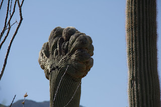
The next several are of a cristate or "crested" saugaro...

Scientists are not sure why some saguaros do this
but about 1 in 250,000 do!


Crazy, huh?
Sagauro blooming
Brown-headed cowbird - one of my least favorite birds since they add their eggs to the nests of smaller unsuspecting birds. The young cowbirds then crowd the smaller nestlings out :(

We also traipsed through strands of mesquite along the Deer Valley wash. They're all in bloom right now.

Deer Valley wash
That's me slogging it up the wash
Mesquites in the wash
Mesquite blossoms
As we neared the end of the trail, we found this cholla with funny scars on it.


This little guy was sooo cute!
Oh noooooooo, Mr. Cholla!
One last giant saguaro cactus
Take the picture already!
Here's DC (Dear Chino) still smiling at the end of the hike.


One thing that seemed to help today, besides the well-placed trail marker system, was the geo-caching GPS "toy" (Magellan eXplorist GC) that DC recently found at Target. It's meant to help find geo-caches, but he was able to put route flags on it from home last night that reassured us we were on the right path. That's sure to be helpful on those less obvious trails.


I attempted (without binoculars) to mentally tally the bird species today:


Mourning dove
White-winged dove
Brown-headed cowbird
Cactus wren
Curved-billed thrasher
Gila woodpecker
Lesser goldfinch
Gambel's quail
Greater roadrunner...


and lots I couldn't identify. Boy, my birding skills are feeble-izing! Next time I think I'll bring my bins to see what else I can find! 
In all it took us about 3 hours to hike the 4 miles. Much better than 2 weeks ago. We will need to be starting earlier very soon. It was a very comfy 56 degrees when we started at 7am, but 88 by the time we got back to the car at 10am! I also think we need to start bringing some bug spray. Lots of gnats around us today. I'd love suggestions on where we should hike next. Sabino canyon? Mount Lemmon? Tucson mountains? Some many hikes, so little time!


Wow! This has been a loooonnnngggg post and if you've read to the bottom, thanks! :)